GIS成果 · 九图对齐图版
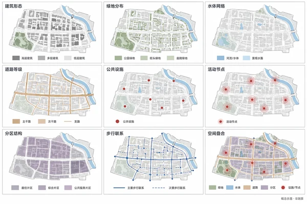
把已有 GIS 成果统一成九图图版;默认展示虚构片区的分类示意,不生成未经计算的数值结果。
Prompt
Create a landscape 3:2 GIS presentation board on white, nine equally sized square maps in a 3x3 grid, thin grey frames, consistent margins and gutters. All maps share the exact same extent, orientation, crop, building footprints and street base. Each panel has one concise dark-grey heading above and only its necessary categorical legend below, aligned to common baselines. Panel order: 建筑形态, 绿地分布, 水体网络; 道路等级, 公共设施, 活动节点; 分区结构, 步行联系, 空间叠合. Pale-grey bases, sage green spaces, grey-blue water, light-ochre roads, brick-red facilities and activity nodes, three muted violet-grey zoning classes, thin dark-blue pedestrian connections and legible transparent overlays. Flat colours, sharp lines, centered maps, no browser or GIS software interface. If actual GIS analysis outputs are supplied, only harmonize styling, legends and layout while preserving their data, class thresholds, units, extents and computed results. Mark a missing layer 缺少数据 instead of fabricating it. Never infer population, floor-area ratio, heatmaps, solar hours, wind speeds, travel-time isochrones or engineering conclusions from a satellite image. With no input create an original fictional district: an east-west main road, four courtyard blocks each north and south, a southwestern park, a northeastern curved creek with two short bridges and six civic facility nodes. Repeat identical geometry across the nine maps and highlight only the named categorical layer. No numeric scales or real place names. Small footer 概念示意·非测算 at bottom right; no other prose or watermark.